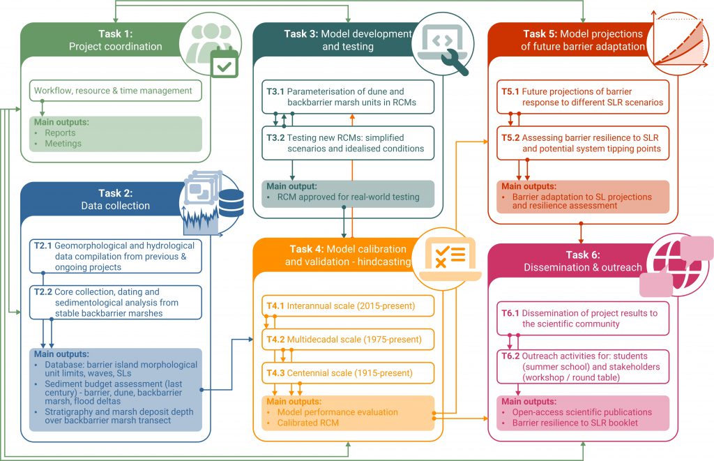
Task 1: Project coordination
Task 1 is a purely administrative and coordinative task. Its focus is on facilitating workplan implementation, overseeing resource and time management and coordinating all economic and administrative procedures. The members responsible for the individual tasks (list given below) will participate in T1 and will be assigned the responsibility of coordinating communication (within and) between tasks and reporting. Logistics regarding fieldwork campaigns (allocating funds, obtaining permits, etc) will also be handled within this task.
Regular meetings will be scheduled after the kick-off meeting of the project, to ensure timely achievement of milestones and resolution of issues that may arise. Potential delays and unforeseen problems with the execution of the plan will be addressed through dedicated meetings. T1 will also oversee dataflow and communication between tasks and adherence to the timeline and will be responsible for overall reporting to FCT.
Duration: 36 months (24/07/2025-23/07/2028)
Task responsible: Katerina Kombiadou
Task 2: Data collection
Aim of the task is to compile all data necessary to apply and test the model for the hindcasting simulations. These will include barrier morphological data and oceanographic forcing (waves and sea-levels) during the last century (T2.1) and data on backbarrier marsh stratigraphy (T2.2).
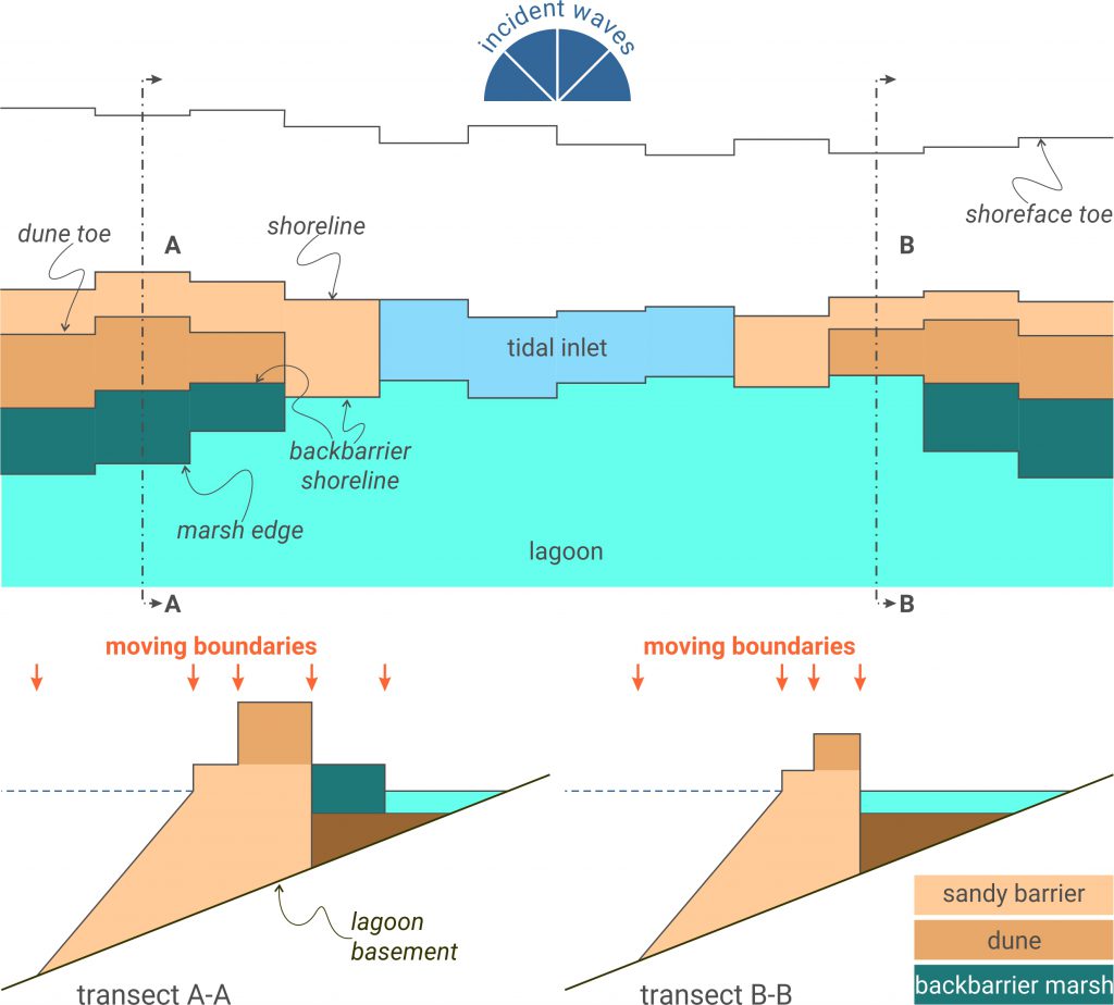
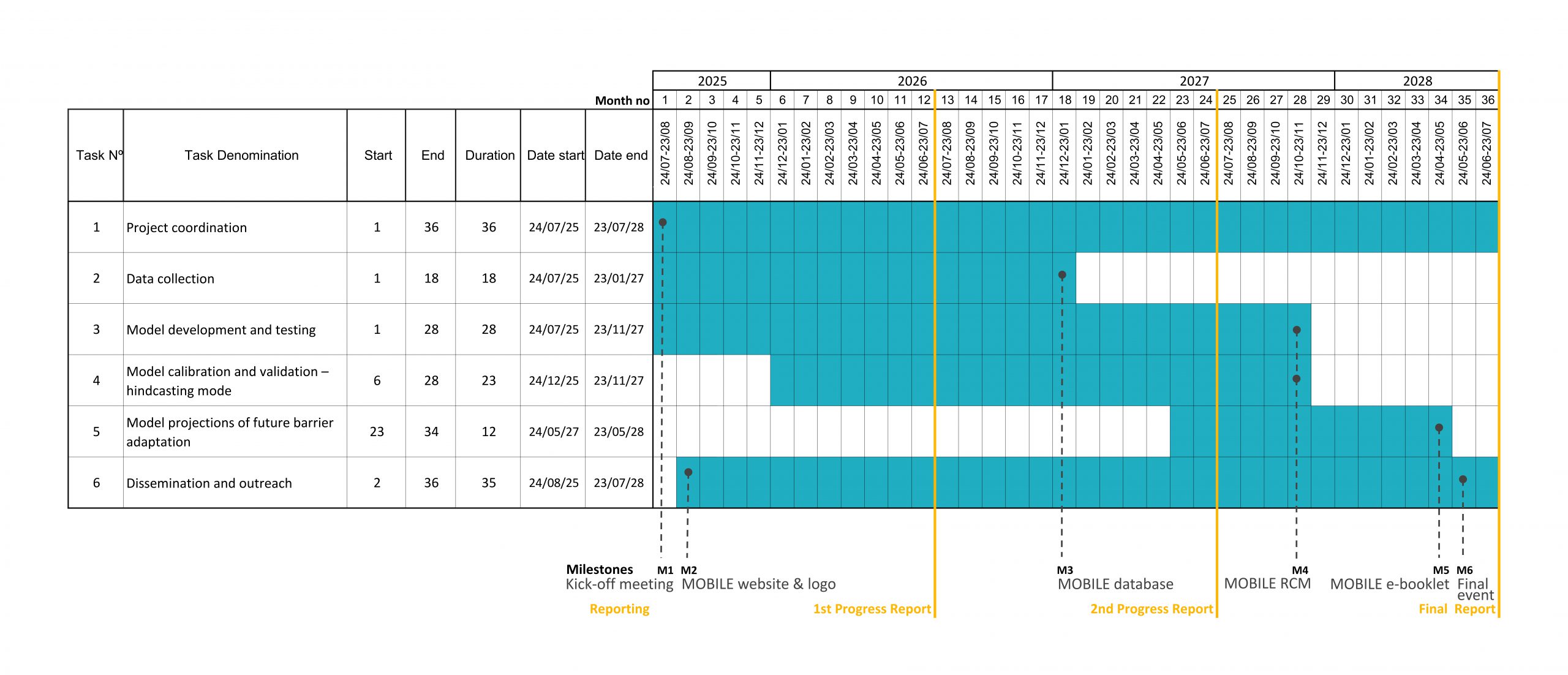
The morphological data compiled in T2.1 will include mapped ‘boundary lines’ (from vertical aerial photos, maps, satellite images) that, in groups of two, delimit the 3 barrier morphological units to be included in the RCM (beach, dune and marsh): oceanside coastline, dune toe, sandy backbarrier edge and lagoon-side marsh edge (where present). Additionally, flood deltas will also be mapped, when possible (e.g., when clearly visible), to allow sediment budget calculations. The bulk of this data will be derived from other projects (Fig. 2). Long-term (1952 to 2014; multi-annual step between mappings) data are readily available from the EVREST project database (Kombiadou et al., 2020), derived from vertical aerial photographs. It will be complemented by satellite-derived shorelines from the ongoing CREST project (http://doi.org/10.54499/2022.05392.PTDC), to extend the EVREST dataset for the last decade (2015-present) and provide higher frequency data (e.g., annual), allowing to identify shorter-term morphological changes in the units of interest. Morphological changes prior to 1952 (earliest available high-quality aerial photo of the RF barriers) will be complemented with available historical maps. Thus, the compiled data will serve to obtain changes of the barrier morphological units between the early 1900s and the present in three overlapping periods of gradually increasing temporal scale (Fig. 2): a) interannual (2015-present), b) multidecadal (1975-present), and centennial (1915-present).
Collected data will also be used to calculate the sediment budget of the morphological units considered (barrier, dune, marsh and flood deltas) in the analysed timeframe, taking into account available data for beach and dune nourishments in the barriers. Necessary hydrodynamic data for the corresponding periods will be collected from model (e.g., ERA5 and CERA-20C) and in situ data for offshore wave conditions and SLs (e.g., Faro & Gulf of Cádiz buoys; Lagos & Huelva tide gauges). A timeseries of schematised wave conditions (Roelvink & Costas, 2019) will also be formulated, to allow for longer-term RCM simulations.
Lastly, sediment data will be compiled from cores that will be collected over cross-shore transects along the broad backbarrier marsh platforms (available for barrier rollover) of Armona and Tavira Islands (T2.2). Even though the age of these marshes well-exceeds the hindcasting horizon of the project, knowledge on the substrate stratigraphy and sedimentary facies of the present-day marsh platform will serve to identify the type of sediments that could potentially be exposed to ocean conditions under intense retreat in the future (e.g., in case of an inlet breach fronting the area). Identifying the extent (depth) of marsh deposits along the backbarrier platform is a priority objective that will allow to consider the potential erodibility of mature marsh deposits in the model (in T3 and T5; Fig. 1).
The compiled database (Milestone 3) will provide input data for T3 and T4.
Duration: 18 months (24/07/2025-23/01/2027)
Task responsible: Susana Costas
Task 3: Model development and testing
The task aims at extending RCM(s) towards including missing morphological units (dune and backbarrier marsh), where necessary, (T3.1) and testing their performance against idealized scenarios of barrier response (T3.2). The selection of RCMs for testing in T3 will be based on completeness of processes and environments included and the potential to incorporate processes or to couple individual RCMs.
The advancement of the selected RCM approach (T3.1; Fig. 3) will imply changes to the parameterisations of overwash and incorporation of simplified, physics-based approximations for the evolution of new units (dune and backbarrier marsh). The overwash parameterisation will be adjusted to: a) account for the presence of the dune in the exposure of the barrier stretch to overwash and b) calculate transfer of sand from the dune to the backbarrier. Dune unit height recovery can be incorporated assuming passive adaptation (e.g., assigning a dune accretion rate during periods with adequate beach widths and no overwash, and a maximum dune height value). In terms of the backbarrier environment, the presence of marsh platform will be included in the model to provide accommodation space for barrier transgression. The erodibility of the marsh in case of exposure to waves (depletion of sandy barrier fronting the marsh stretch) will be linked to its maturity, width and to the depth of the marsh deposit. For example, young and shallow marsh patches can be considered easily erodible (no different than the sandy barrier, allowing for breaching), while a significantly higher resistance to erosion will be assigned to mature, deep and compacted backbarrier marshes (from T2.2). The morphological unit evolution will be incorporated in a simplified way, for example, assuming uniform vertical growth (e.g., backbarrier marsh accreting at pace with SLR) and lateral edge rates determined by the sand volumes that reach the lagoon during overwash (function of overwash volumes and backbarrier marsh width) (Lorenzo-Trueba & Mariotti, 2017). If the marsh edge borders a frequently dredged channel the marsh edge position may be considered fixed (marsh squeeze).
The idealised experiments (T3.2) will focus on testing the ability of the RCM to reproduce anticipated morphological changes (i.e., long- and cross-shore growth, coastal retreat, breaching, rollover, and drowning) under controlled and stable forcing conditions and considering simplified initial barrier morphologies. For example, high LST supplies over an idealised and simplified initial barrier morphology and under conditions of stable SL should promote longshore growth (and inlet migration) and shoreline advance in barrier zones updrift. Conversely, reduced LST values should induce coastal retreat and eventually a barrier breach. Storm waves would be expected to increase overwash and, depending on the intensity and frequency of the storms and on the SLR imposed, can lead to barrier transgression or drowning. Similarly, inlet stabilisation with hard structures should cause accumulation updrift and erosion downdrift (as well as a shift in tidal prism). Successfully reproducing these responses after the inclusion of the new morphological units of dune and marsh will provide confirmation that the model is indeed capable of reproducing theoretical barrier response and can be considered for calibration and validation against real-world conditions (in T4).
Duration: 28 months (24/07/2025-23/11/2027)
Task responsible: Rui Taborda
Task 4: Model calibration and validation – hindcasting mode
The task will use the model developed and tested in T3 and apply it in hindcasting mode to calibrate and validate its performance, using the data collected in T2. Using an up-scaling approach, the simulation periods will be extended from interannual (T4.1), to multidecadal (T4.2) and to centennial (T4.3) timescales of barrier change. The gradually increasing and overlapping simulation windows (Fig. 2) will allow to resolve scaling issues and to tune dominant processes over each timescale. Simulations will also serve to assess the loss of detail associated with the reduction of complexity (necessary for long-term simulations) and, eventually, the suitability of the complexity reduction, as the temporal step and simulation window are increased. The work within this task, along with the theoretical tests performed in T3, are expected to constrain the uncertainties for the future projections of barrier morphologic response (T5).
At the interannual scale (T4.1; 2015-present), hindcasting will allow to tune the model to reproduce the coastal imprint of intense storms (cumulative change by storm erosion and post-storm recovery) and dominant short-term morphodynamics and other fundamental processes (e.g., inlet migration) over calm periods.
At the multidecadal scale (T4.2; 1975-present), the RCM will be calibrated and validated against a wide range of barrier island morphological adaptation to human interventions (Kombiadou et al., 2019): a) alongshore growth initiated by artificially-induced loss of inlet tidal prism, b) alternating stretches of coastline progradation and retreat in wide barriers, minimally impacted by human interventions, and c) barrier rollover, initiated by human-induced LST reduction, and gradual reestablishment of stable backbarrier conditions, followed by shoreline progradation. In terms of (non-stabilised) inlet morphodynamics, the multidecadal timeframe includes one naturally stable (reducing in width) inlet and two migrating ones. Therefore, the RCM will be calibrated over an ample range of barrier geomorphic response to both constructive and destructive processes and model skill will be assessed over these conditions.
Over the centennial scale (T4.3; 1915-present), the hindcasting window will be extended to include the phase of naturally evolving barriers (1915 to 1940s) and the impact of artificial inlet stabilisations (Kombiadou et al., 2019), namely the: a) doubling of the elongation of Culatra island, b) drowning of the Cacela spit end and c) formation of Cacela island at a landward position. The work performed in T4.3 will allow to calibrate the RCM and assess its skill over mesoscale barrier morphodynamics, which is critical for increasing the confidence in future projections.
A contingency plan is foreseen in case of inability to reproduce a documented barrier response in T4, in which case the work will return to T3 (link from T4 to T3 in Fig. 1), test new approaches and reconfigure the RCM to solve the issue.
The model will be published in an open-access repository (Milestone 4).
Duration: 23 months (24/12/2026-23/11/2027)
Task responsible: Katerina Kombiadou
Task 5: Model projections of future barrier adaptation
Task 5 will transfer the RCM, calibrated and validated in T4, to future projections of barrier morphodynamic adaptation to SLR along the eastern flank of RF (T5.1) and assessment of their future resilience (T5.2).
The simulations of barrier island adaptation (T5.1; e.g., present to 2100) will consider two emission scenarios, one moderate and one pessimistic (e.g., SSP2-4.5 and SSP5-8.5; IPCC, https://sealevel.nasa.gov/ipcc-ar6-sea-level-projection-tool), for which the related regional SLR and wave projections will be obtained by available model datasets (e.g., from COWCLIP and Copernicus Climate Change Service). Based on the results and on wave statistics for the projected climate, a synthetic schematised wave timeseries will be compiled, that will account for the storminess evolution foreseen in each scenario.
The uncertainty propagation within the RCM projections (Fig. 5a) will be tackled following an ensemble approach, fuch as running multiple simulations over a range of forcing conditions (e.g., -10% to +10% storminess for each wave scenario, different percentiles in SLR probabilistic projection) and calculating the ensemble morphological change can provide better constraints to model divergence, while separating the projection horizon into smaller forecasting windows (i.e., 25-yrs) can serve to control error propagation. The uncertainties associated with the SLR scenarios and wave projections and the impact on the RCM results will be estimated and considered in the assessment of future resilience (in T5.2).
T5.2 will analyse the results of barrier island geomorphologic adaptation for the climate scenarios, to identify critical thresholds and tipping points, beyond which barrier islands may experience irreversible changes or increased vulnerability to climate change (SLR and storminess). The analysis will be based on the barrier island resilience assessment methodology developed for and applied in the RF (Kombiadou et al., 2020). The methodology considers the same morphological units (barrier-dune-marsh) that will be included in the RCM, allowing seamless transition from the model outputs to determining resilience trajectories and dimensions. The outputs of T5.2 will include in-depth analysis of changes to the barrier stability landscape (barrier latitude and precariousness) and potential future barrier state shifts (i.e., location, type and permanence of thresholds) for the climate scenarios tested. Based on the results and potential system tipping points identified, a series of measures (e.g., nourishments, dune restoration, living shorelines) will be tested with dedicated model runs to evaluate their effectiveness in mitigating climate change impacts on barrier islands. The results will be put forward for consultation and discussion with the relevant governmental agencies (Agência Portuguesa do Ambiente (APA), Instituto da Conservação da Natureza e das Florestas (ICNF), Direção-Geral de Recursos Naturais, Segurança e Serviços Marítimos (DGRM); in T6.2) and will be used to compile an e-booklet for dissemination to the public (Milestone 5).
Duration: 12 months (24/05/2027-23/05/2028)
Task responsble: Carlos Loureiro
Task 6: Dissemination and outreach
Task 6 will be responsible for the dissemination of the project results and findings to the scientific community and targeted stakeholders and for science communication activities. The aim of the task is to increase the visibility of the project and the outreach of the results, not only to academia, but also to the relevant administrative bodies and the local community. To this aim, the activities planned within the task are:
• The project website will be created and published online within the 1st month (Milestone 1) and, along with other online platforms (e.g. social media of CIMA-UAlg, FCiências.ID and IPMA), will be used to share updates, events, findings and deliverables throughout the course of the project, ensuring accessibility to a diverse audience and fostering broader public engagement.
• Research findings will be published in open-access, peer-reviewed scientific journals (at least 3 foreseen) and presented at national and international conferences (at least 6 foreseen).
• The MOBILE e-booklet, an electronic short publication that will communicate the main results on the future resilience and adaptation of the east Ria Formosa barriers to sea-level rise to the public, will be produced and made available through the project webpage (Milestone 5).
• A summer school on ‘Long-term coastal morphodynamics and modelling’, directed to PhD and master’s students, will be planned for the 3rd year of the project.
• Science communication activities with primary and secondary school students will be organised with the assistance of the Portuguese national network of science dissemination centres (Centros de Ciência Viva) of Faro and Tavira, who are longstanding partners of CIMA-UAlg, and will facilitate the contact between project partners and schools. Educational materials (e.g., infographics and videos) to communicate key project findings and raise awareness will also be prepared and disseminated to the public onsite at the centres of Faro and Tavira (e.g., video projections), via their websites and through the MOBILE webpage.
• The final event of MOBILE is planned for the final month of the project (Milestone 6). It will be a workshop where the results from the future simulations and potential mitigation measures (from T5) will be presented and discussed with targeted stakeholders (government agencies such as APA and Parque Natural da Ria Formosa, City Councils of Faro, Olhão and Tavira, interested citizen groups like the Associação de Moradores da Ilha da Culatra, etc.) in the format of a round table discussion. This will provide a platform for dialog and knowledge sharing and will enhance the relevance of the project results to real-world decision-making.
In terms of training, three master’s student scholarships are foreseen within the project.
Duration: 36 months (24/07/2025-23/07/2028)
Task responsible: Teresa Drago